


A SMALL CRAFT/HIGH SURF ADVISORY REMAINS IN EFFECT FOR ST. MAARTEN…
DATE ISSUED: Friday, September 20, 2019
TIME ISSUED: 02:30 PM (18:30 UTC)
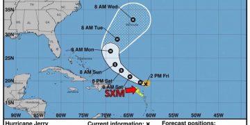
…JERRY’S RAINBANDS APPROACHING ST. MAARTEN…
Location: Lat. 19.2 N, Lon. 61.2 W
About: 149 miles…239 km ENE of St. Maarten
Maximum sustained winds: 80 mph…130 km/h
Present Movement: WNW…295 degrees at 17 mph…28 km/h
Minimum Central Pressure: 990 mb…29.24 inches
DISCUSSION AND 24-HOUR OUTLOOK
Hurricane Jerry is weaker is still a Category 1 hurricane, moving toward the west-northwest near 17 mph (28km/h).
On the forecast track, the center of Jerry is expected to pass approximately 120 miles to the north of St. Maarten late tonight. Effects of Jerry on St. Maarten are expected to be mainly in rainfall and sea swells from later this
afternoon and tonight.
Maximum sustained winds have further decreased to near 80 mph (130 km/h) with higher gusts.
Further weakening is forecast during the next day or so, with some re-strengthening possible early next week.
Hurricane-force winds extend outward up to 15 miles (30 km) from the center and tropical-storm-force winds extend outward up to 80 miles (130 km).
Residents and the general public are advised to continue being alert and monitor the progress of Jerry.
The Meteorological Department of St. Maarten will continue to monitor and issue special weather bulletins.
POTENTIAL IMPACTS FOR ST. MAARTEN:
Rainfall: Jerry is expected to produce total rainfall accumulations of 1 to 4 inches. Increasing cloudiness with showers and thunderstorms are expected as the day progresses. Most of the significant showers are expected from later this evening into Saturday. Flooding and/or rock slides can be expected in flood-prone areas and along hillsides. Residents and users of these areas are advised to be vigilant.
Winds: Gusty winds could accompany showers later today through Saturday.
Seas: Swells up to 12 feet are possible during the passage of Hurricane Jerry, mainly along the northern and eastern shores. These swells are likely to cause life-threatening surf and rip current conditions. Beach erosion is possible in vulnerable areas. Sea-bathers are advised to stay away from the sea during the passage of Jerry.


